
Viz World User Guide
Version 17.0 | Published January 24, 2018 ©
Street Labels
![]()
The plugin can be found in the folder: Viz Artist 3: Built Ins -> Geom Plugins -> Maps.
The Street Labels plugin can be used for drawing street labels. Until now the solution was to use Viz objects to draw street labels where the main drawback was the number of labels required. Using Viz objects you are limited to 300 to 500 containers before Viz no longer is able to render in real time.
The Street Labels plugin draws the street labels by itself and by doing so it can holds over 100.000 labels.
Since it is not an object designed in Viz Artist the only freedom you have is the font used and relative position and scale, the Street Labels plugin will only work for Navigator scenes.
To enable the use of the plugin (as opposed to designing your own street labels) you need to set under Label Manager’s Auto Labels tab the level of Road Labels to be shown. The Road Labels option defines the level (number) of road labels that will be displayed (zero (0) means no labels). You also need to set the label style to be Internal (Open GL).
Properties
-
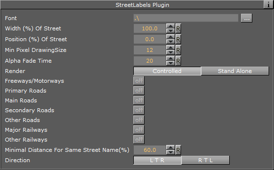
Font: Defines the font used for drawing the labels.
-
Width: Defines the width of the label in relation to the width of the street.
-
Position: Defines the position of the label in relation to the center of the street.
-
Min Pixel drawing size: Defines the minimum number of pixels used to draw the labels. If the number of pixels is smaller than the current labels (based on parameters above and the width of the street) the label will not be drawn. The number must be smaller than the maximum width numbers in the 3D Roads plugin design.
-
Alpha Fade time: Defines the number of frames used to fade in or out when label’s status changes.
-
Render: If controlled is enabled the plugin will draw the streets that belong to the 3D Roads plugin above it, if Standalone is enabled the following settings will apply:
-
Primary Roads, Main Roads, Secondary Roads, Other Roads, Major Railways and Other Railways
-
-
Minimal Distance for Same Street Name (%): Distance in screen percent for showing the same street name twice.
-
Direction: Defines the direction of the label. Options are Left to Right (LTR) or Right to Left (RTL) (not complex script).