Viz World User Guide
Version 17.0 | Published January 24, 2018 ©
Locator Control
![]()
The plugin can be found in the folder: Viz Artist 3: Built Ins -> Container Plugins -> Maps.
The LocatorCtl plugin is used to link an object positioned on one map to another map, showing its position. The object marking the point on the linked map must reside under a geographically referenced map. The linked object will show the position of the linked map or object on the map its parent map.
-
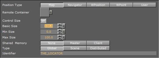
Position Type: Defines the link between the object and the map. Available options are Map, Navigator, WPosition, WPoint and User.
Map

Map links the object to a map, showing its entire area over the parent map.
-
Remote Container: Defines the linked map container.
-
Control Size: When disabled (Off), the entire area of the linked map will be marked on the parent map. When enabled (On), the size of the marked area can be controlled.
-
Basic Size: Defines the percentage of the linked map area to be marked.
-
Min Size: Defines the minimal size of the linked map area to be marked.
-
Max Size: Defines the maximal size of the linked map area to be marked.
-
Shared Memory Link: Defines which is the master (source) and client (target) when the same Shared Memory Identifier is used.
-
Type: Defines the accessibility of the shared memory.
-
Global: Memory is accessible to all scenes currently loaded in memory. This is useful when working with Transition Logic scenes where your Viz World map can be one scene and the locator a different one and data can easily be transferred between the two.
-
Scene: Memory is only accessible locally and to the current scene. Every scene has one shared memory map that can be used to exchange data among the scripts in the scene.
-
Distributed: Memory is accessible to all computers connected to one Viz Graphic Hub.
-
-
Identifier: Defines the identifier for the shared memory map.
WPosition
WPosition links the object to a WPosition plugin, showing its position on the parent map. Remote Container defines the linked WPosition container.
WPoint
WPoint links the object to a WPoint plugin, showing its position on the parent map (the WPoint plugin is used in Viz Weather). Remote Container defines the linked WPoint container.
User

User enables the user to position the object on the map.
-
Map Center Longitude: Defines a Longitude value for the object.
-
Map Center Latitude: Defines a Latitude value for the object.
-
Tangent To Globe: When enabled (On), the controlled object will be rotated to match the globe surface.
Note: Tangent To Globe is only visible when the locator is under a globe object.