
Viz World User Guide
Version 17.0 | Published January 24, 2018 ©
Map Tiler
![]()
The plugin can be found in the folder: Viz Artist 3: Built Ins -> Container Plugins -> Maps.
The Map Tiler plugin is used to build a set of map tiles for displaying an area in high resolution. The maps are created as GeoImage (flat map) or Globe objects and placed under a low resolution map of the entire area for geographical referencing. The .Map Tiler v17.0 plugin is also used for managing Pyramid object maps when used in a scene (see the Map Pyramid plugin for more information).
IMPORTANT! Do not modify the container hierarchy under the MapTiler container.
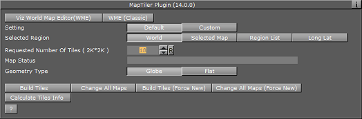
This section contains information on the following tabs and buttons:
Default
-
Selected Region: Defines the area of the map for which the tiles will be created.
-
World: Creates tiles for the entire world.
-
Selected Map: Creates tiles for the area of the selected map in the CWMClient plugin attached to the MapTiler container.
-
Region List: When Region List is selected, a list of regions will be displayed. An item from the list can be selected to create map tiles for the selected area.
-
Long Lat: Sets the Longitude and Latitude minimum and maximum values. The map tiles will be created for the defined area. When Long Lat option is selected, additional fields will be enabled.
-
-
Map Status: Displays plugin status messages. When configuring the tiles, the Map Status field will display the number of tiles required and tile size according to the current plugin setup.
-
Requested Number of Tiles (2K2K): Allows the user to set the number of tiles to create
-
Geometry Type: Selects the object type of the created tiles.
Selected Map
-
Texture Compression: Sets the compression level for the texture (DTX5 is the highest compression level which is less texture quality).
-
Get Map Resolution/(Classic): Use the WME editor (New or Classic) to zoom to the closest level you want the tiles to support. If you change the extent (in Selected Map mode) you will need to set the resolution again.
Region List
-
Region Area: Select the region you want to build tiles for.
Long Lat
-
West: Sets the Longitude value for the western edge of the map.
-
East: Sets the Longitude value for the eastern edge of the map.
-
South: Sets the Latitude value for the southern edge of the map.
-
North: Sets the Latitude value for the northern edge of the map.
Custom
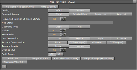
The following additional parameters are available:
-
Radius/Map Size: Sets the size (in Viz units) of the globe or map tiles (all together).
-
Tessellation: The number of polygons used in the object. The higher the number is, the smoother the object is drawn.
-
Texture Quality: When set to Linear the same image resolution will be used in the entire zoom range. When set to Mipmap the resolution is changed according to the distance from the image (managed automatically in Viz Artist).
-
Overlap (%): Percentage for overlapping each tile.
-
Build Terrain: Builds terrain data for the created tiles
-
Smooth Terrain: Smoothens terrain edges so they blend with the base map surface. When enabled (On) the Terrain Smoothing Factor will be enabled.
-
Terrain Smoothing Factor: Sets the percentage of the smoothed area.
-
Terrain Height Scale: Sets the scaling factor for terrain height. The higher the factor is, the more extreme the terrain will be.
-
Terrain Resolution: Sets the total terrain resolution for all tiles. A high resolution value will result in a more detailed terrain (effecting performance).
Buttons
-
Build Tiles: Build the geo-reference map and tiles.
-
Change All Maps: Builds the geographical reference map, tiles and applies style changes made in the CWMClient plugin to all child containers (recursively) under the MapTiler container.
-
Build Tiles (Force New): Builds the geographical reference map and tiles without checking the cache for existing maps (from the server).
-
Change All Maps (Force New): Builds the geographical reference map, tiles and applies style changes made in the CWMClient plugin to all child containers (recursively) under the Map Tiler container, without checking the cache for existing maps (from the server).
-
Calculate Tiles Info: Calculates the tiles information, without building the tiles, and displays it in the Map Status field.