
Viz World User Guide
Version 17.0 | Published January 24, 2018 ©
3D Road Manager
![]()
The plugin can be found in the folder: Viz Artist 3: Built Ins -> Container Plugins -> Maps-Man.
The 3DRoadManager plugin is used for creating 3D Roads objects. The plugin uses a shape file design to create roads according to the defined settings.
Properties
-
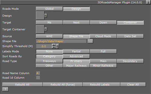
Roads Mode:
-
Global: Applies one set of road design for all roads
-
Design: uses a design per CWMClient. The Design field sets the roads design container that is used for building border data from a shape file. The design container should be built with a 3DBorder object and a material. No special naming convention is required.
-
-
Target: When Roads Mode is set to Design, this defines the container to be used as the parent container for the road designs.
-
Me builds the 3DRoads objects under the current container (holding the 3DRoads Manager plugin).
-
Next builds the 3DRoads objects under the next container (next container in the tree and at the same level as the 3DBorderManager container).
-
Down builds the 3DRoads objects under the first child container.
-
Container builds the 3DRoads objects under the container dragged into the Target container place holder. The Target Container specifies the container that will hold all the 3DBorder objects.
-
-
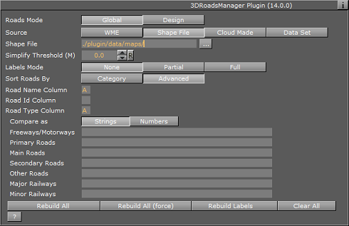
Source: Select street/road source.
-
WME: Viz World Map Editor (WME) using the CWM client plugin to connect to the map server
-
Shape File: Shape file that contains street data.
-
Cloud Made: Load street data from Cloud Made. This is a web service which requires a license.
-
Data Set: Load street data from the converted data supplied by an external provider into Viz World format
-
WME
-
Simplify Threshold: Sets the detail reduction factor for the shape of the roads.
-
Select Streets (WME): Opens the World Map Editor .
-
Select Streets (Classic): Opens Map Editor Classic .
-
Labels Mode: When set to None, no labels will be created, Partial will only create labels visible on the view, All will create all labels.
-
Labels Only: When set to ON, only the labels will be created, but not the roads.
-
Cloud Made
-
Simplify Threshold: Sets the detail reduction factor for the shape of the roads.
-
Labels Mode: When set to None, no labels will be created, Partial will only create labels visible on the view, All will create all labels.
-
Labels Only: When set to ON, only the labels will be created, but not the roads.
-
Data Set
-
Data Set: Location of data
-
Simplify Threshold: Sets the detail reduction factor for the shape of the roads.
-
Labels Mode: When set to None, no labels will be created, Partial will only create labels visible on the view, All will create all labels.
-
Labels Only: When set to ON, only the labels will be created, but not the roads.
-
Shape File
-
Shape File: Defines a path to the shape file (*.shp), containing the border definitions. Shape files are bought from vendors specialized in Geographic Information System (GIS) and holds the actual shape data; polygons, splines, and others. Note that shape files must be stored in individual folders.
-
Sort Roads By: Sets the loaded roads from the shape file in a category.
-
Category enables the user to select one predefined category of street data. Available Road Types are Freeways, Primary, Main, Secondary and Other.
-
Advanced splits the data into different categories using specific string types. Road Type Column specifies a column name that holds each road category. Freeways/Motorways, Primary Roads, Main Roads, Secondary Roads and Other Roads specify what string in the database file (*.dbf) that matches the road type.
-
-
Persistent Roads: Defines whether the roads data is removed from Viz memory when the scene is closed or not.
-
Sort Roads By: Defines which road type will be associated to the created objects. If Advanced is selected, additional parameters will be enabled allowing the configuration of road types according to the data associated to the shape file.
-
Category: Enables the selection of road types. Available options are: Freeways, Primary Main, Secondary, Other.
-
Advanced: Sets parameters according to the data in the files associated with the shape file. Defines the road type column and the specific road type Id in the file.
-
-
Road Name/Id Column: Column which holds the Name/ID of the road.
Buttons
-
Rebuild All: Rebuilds all data. If Roads mode is set to Design, 3DRoads objects will be created from design. If Roads mode is set to Global, global 3DRoads renderers will render built data.
-
Rebuild All (force): will delete any cache and force a rebuild of the cache as well as rebuilding the Viz geometry.
-
Rebuild Labels: will rebuild only the labels but will not affect streets already built.
-
Clean All: Cleans Target container from sub containers.