
Viz World User Guide
Version 17.0 | Published January 24, 2018 ©
CWMClient
![]()
The plugin can be found in the folder: Viz Artist 3: Built Ins -> Container Plugins -> Maps.
The CWMClient plugin is the main plugin in the Viz World Client (WoC). The CWMClient plugin launches the World Map Editor (WME) and retrieves the map from the Viz World Server (WoS) after the user has applied the changes to the map in WME.
Note: The plugin uses the VizMapsManager.dll to connect to the Viz World Server machine configured in Viz Config page.
The CWMClient plugin has various different plugin editor views and buttons:
Texture
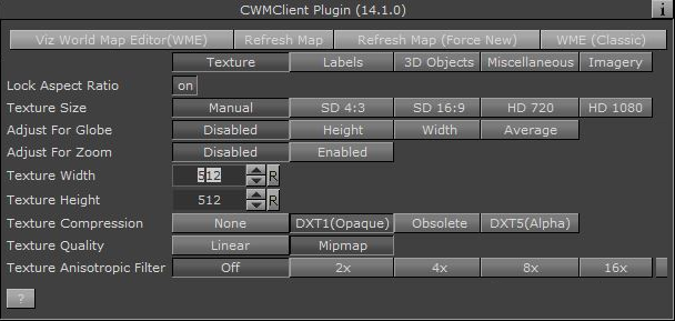
The texture section defines the geo map image parameters:
-
Lock Aspect Ratio: Effects texture height and texture width parameters. When enabled (On) any change in the texture height or width will affect both parameters. When disabled (Off), each parameter is controlled separately.
-
Texture Size: Presets for texture sizes.
-
Auto Adjust To Globe: If texture size is other than manual, this parameter defines whether the texture size will be modified when mapped on a globe. This option is used when displaying maps that are close to Earth’s poles.
-
-
Adjust for Globe (advanced): Adjusts a 2D selection in WME converting it to 3D.
-
Adjust for Zoom (advanced): Normally the selected map is zoomed in by approximately 10 percent in order to avoid the fade area. By enabling Adjust for Zoom a wider map than the selected one is fetched such that the final selection better equals the map selected in WME.
-
Texture Width: Defines the number of pixels in the map width. When aspect ratio is locked, changing the texture width will automatically change the Texture Height parameter.
-
Texture Height: Defines the number of pixels in the map height. When aspect ratio is locked, changing the texture width will automatically change the Texture Width parameter.
-
Texture Compression: Sets the compression level for the texture (DTX5 is the highest compression level, i.e. less texture quality).
-
Texture Quality:
-
Linear: Use the same image resolution in the entire zoom range.
-
Mipmap: Change resolution according to the distance from the image (managed automatically in Viz Artist).
-
-
Texture Anisotropic Filter: (Off/2x/4x/8x/16x) Turn on the relevant anisotropic in the image on the same container with CWMClient (similar to Mipmap, above).
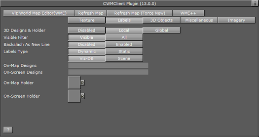
Labels
-
3D Designs & Holder: Defines the labels usage and behavior over the map, and has three available options:
-
Disabled: Labels produced by the Viz World Server will be displayed as part of the map texture. No manual definitions are required.
-
Local: Requires you to manually define the 3D Designs & Holder path (e.g. On Map Designs: Vizrt/VizWorld/GlobalDesigns/Regions/)
-
Global: Enables you to use a global design defined by the 3D Map Setting Plugin scene plugin.
IMPORTANT! Global labels will not work with on screen labels so you will still need to configure them (if needed).
-
Local and Global
-
Visible Filter: Select All to build all labels defined in WoC. Select Visible to build only labels that are shown on the selected map.
-
Backslash as New Line: When Enabled you can add labels with more than one line typing backslash “\” as a separator for each new line.
-
Labels Type: Defines the source of the label designs. Available options are Dynamic and Scene. Selecting Viz-DB or Scene defines where the label designs are stored.
-
Dynamic: Dynamically creates new labels based on label designs created in the scene itself or fetched from the Viz Graphic Hub (Viz DB). All designs are referenced by the On-Map Designs placeholder. When selecting labels in the Map Editor (WME) all your labels will be dynamically added underneath the CWMClient’s container and receive the correct label type (provided it is defined by your label design). Note that this approach does not allow you to use control plugins. As the number of labels are dynamic this approach does not allow you to use control plugins.
-
Static: Unlike the Dynamic label type, Static will not create new labels underneath the CWMClient’s container, but will instead use the number of labels already defined by the designer (achieved by adding copies of the label designs as sub containers of the CWMClient’s container). As the number of labels and label types are static this approach allows you to use control plugins.
-
Viz-DB: Label source is a merged object from the Viz objects library, containing the label designs.
-
Scene: Label source is a group container in the scene hierarchy, containing the label designs.
-
-
On Map Designs: (Local only). Defines the source of the labels that are displayed on the map. When Viz DB (Viz Graphic Hub) is selected, define the path to a merged object, containing the label designs, in Viz object library. When Scene is selected, drag a group container with the label designs to the container place holder.
-
On Screen Designs: Defines the source of the labels that are displayed on a plane in front of the screen. When Viz DB is selected, define the path to a merged object, containing the label designs, in Viz object library. When Scene is selected, drag a group container with the label designs to the container place holder.
-
On Map Holder: (Local only). This parameter is a container used for grouping all the generated labels on the map. When a map with labels is selected, the plugin will duplicate the label designs and create the labels. The duplicated labels will be placed under the _On Map Holder _container.
-
On Screen Holder: (Local only). This parameter is a container used for grouping all the on screen labels (labels that are not geo-referenced) used in the map. When a map with on screen labels is used and Viz is selected, the on screen label designs will be copied to the holder container and the label information will be sent to the copied designs.
Note: Back slash () in label names will be treated as a new line (carriage return).
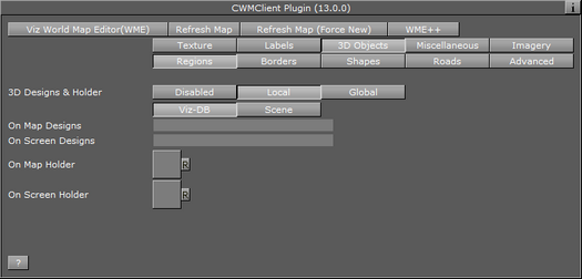
3D Objects
The 3D Objects section defines the other 3D properties of objects on the map, other than labels (regions, roads and so on).
3D Objects and Regions
-
3D Designs & Holder: Defines whether the regions will be part of the received texture or 3D objects. When set to Disabled, regions will be displayed as part of the texture. When set to Local or Global the Viz-DB and Scene parameters are made available. Also, when set to Global, the global region designs and holder will be used to create the O Map 3D region objects. On Screen parameters will be enabled to define the on screen region designs and holder.
Note: The global designs and holder are defined in the 3D Map Setting Plugin scene plugin.
-
Viz-DB: Sets region source to be a merged object from the Viz objects library, containing the region designs.
-
Scene: Sets region source to be a group container in the scene hierarchy, containing the region designs.
-
-
On Map Designs: Defines the source of the 3D Region objects that are displayed on the map. When Viz DB is selected, define the path to a merged object, containing the region designs, in Viz object library. When Scene is selected, drag a group container with the region designs to the container place holder.
-
On Screen Designs: Defines the source of the 3D Region objects that are displayed on a plane in front of the screen. When Viz DB is selected, define the path to a merged object, containing the region designs, in Viz object library. When Scene is selected, drag a group container with the region designs to the container place holder.
-
On Map Holder: This parameter is a container used for grouping all the generated 3DRegion objects on the map. When a map with regions is selected, the plugin will duplicate the region designs and create the 3D Region objects. The duplicated regions will be placed under the On Map Holder container.
-
On Screen Holder: This parameter is a container used for grouping all the on screen regions (regions that are not geo-referenced) used in the map. When a map with on screen regions is used and Viz is selected, the on screen region designs will be copied to the holder container and the region information will be sent to the copied designs.
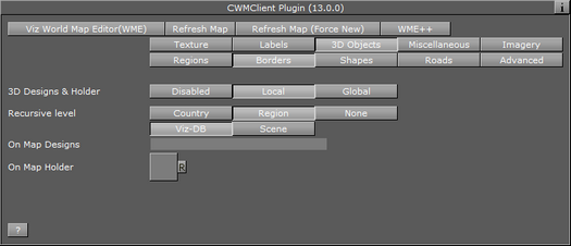
3D Objects and Borders
-
3D Designs & Holder: Defines whether the border line will be part of the received texture or drawn as a 3D object. When set to Disabled, borders will be displayed as part of the map texture. When set to Local the Viz-DB and Scene parameters are made available and the shapes added in the WME will be drawn as a 3D object by Viz. When set to Global, the global border designs and holder will be used to create the 3D border objects.
Note: The global designs and holder are defined in the 3D Map Setting Plugin scene plugin.
-
Recursive level: Sets the filter level for border details. If None is selected, all border data is drawn. If Region is selected, Sub Region data will not be drawn. If Country is selected, region and sub-region borders will not be drawn.
-
Viz-DB: Sets the border source to be a merged object from Viz objects library, containing the border designs.
-
Scene: Sets the border source to be a group container in the scene hierarchy, containing the border designs.
-
-
On Map Designs: Defines the source of the 3D Line objects that are displayed on the map. When Viz DB is selected, define the path to a merged object, containing the border designs, in Viz object library. When Scene is selected, drag a group container with the border designs to the container place holder.
-
On Map Holder: This parameter is a container used for grouping all the generated 3DBorder objects on the map. When a map with borders is selected, the plugin will duplicate the border designs and create the 3D Line objects. The duplicated borders will be placed under the On Map Holder container.
3D Objects and Shapes
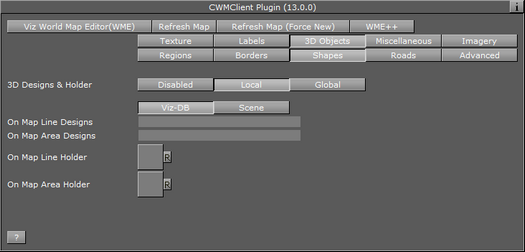
-
3D Designs & Holder: Defines whether the shapes will be part of the received texture or drawn as a 3D object. When set to Disabled, shapes will be displayed as part of the map texture. When set to Enabled the Viz-DB and Scene parameters are made available and the shapes added in the WME will be drawn as a 3D object by Viz.When set to Global, the global shape designs and holder will be used to create the 3D shape objects.
Note: The global designs and holder are defined in the 3D Map Setting Plugin scene plugin.
-
Viz-DB: Sets the shape source to be a merged object from Viz objects library, containing the shape designs.
-
Scene: Sets the shape source to be a group container in the scene hierarchy, containing the shape designs.
-
-
On Map Line Designs: Enables the user to add vector line data to the map. Either by using the draw option in the WME (Add Shape), or from selecting an existing line data (e.g. street).
-
On Map Area Designs: Vector area designs. This option has support for the area draw option in the WME.
-
On Map Line Holder: Defines the source of the 3D Region objects that are displayed on the map. When Viz DB is selected, define the path to a merged object, containing the shape designs, in Viz object library. When Scene is selected, drag a group container with the shape designs to the container place holder.
-
On Map Area Holder: This parameter is a container used for grouping all the generated 3DShape objects on the map. When a map with shapes is selected, the plugin will duplicate the shape designs and create the 3D Region objects. The duplicated shapes will be placed under the On Map Holder container.
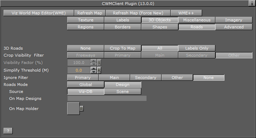
3D Objects and Roads
-
3D Roads: Defines whether the road data will be drawn on the map and the way the roads will be drawn. Available options are None, Crop To Map and All.
-
None: The roads data will not be available to be drawn on the map.
-
Crop To Map: Enables the Visibility Filter and Visibility Factor (%) settings, limiting the roads data.
-
All: Loads the selected road data.
-
Labels Only: only the road labels will be drawn.
-
-
Crop Visibility Filter: Sets the highest level of road type that will be cropped. Available options are Freeway, Primary, Main, Secondary and Other.
-
Freeway: Crops all roads rated as freeways and lower (that is all roads) using the Visibility Factor.
-
Primary: Crops all roads rated as primary roads and lower (that is primary, main, secondary and other) using the Visibility Factor.
-
Main: Crops all roads rated as main roads and lower (that is main, secondary and other) using the Visibility Factor.
-
Secondary: Crops all roads rated as secondary roads and lower (that is secondary and other) using the Visibility Factor.
-
Other: Crops all roads rated as other roads (that is none of the above) using the Visibility Factor.
-
-
Visibility Factor (%): Defines the cropping area of the roads on the map. 100% means the roads will be cropped at the map edges and cover the entire map area. A lower value will cause the selected road types in the Visibility Filter to be cropped (evenly from the map edges).
-
Simplify Threshold (Meters): Applies a simplifying algorithm on road data. The number represents the biggest allowed error.
-
Ignore Filter: Disables creation of roads that are lower or equal to the selection (i.e. Freeway, Primary, Main, Secondary, and Other).
-
Roads Mode: Applies one set of road design for all roads (Global), or uses a design per CWMClient (Design).
-
Source: Sets the source for road designs. Available options are Viz-DB and Scene. Viz-DB sets road source to be a merged object from Viz objects library, containing the road designs. Scene sets road source to be a group container in the scene hierarchy, containing the road designs.
-
On-Map Designs: Defines the source of the 3D Roads objects that are displayed on the map. When Viz-DB is selected, define the path to a merged object, containing the road designs, in Viz object library. When Scene is selected, drag a group container with the road designs to the container place holder.
-
On Map Holder: This parameter is a container used for grouping all the generated 3D Roads objects on the map. When a map with roads is selected, the plugin will duplicate the road designs and create the 3D Roads objects. The duplicated roads will be placed under the On Map Holder container.
-
3D Objects and Advanced
-
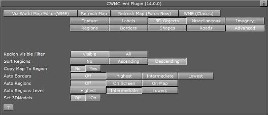
Regions Visible Filter: Defines whether all the selected regions will be created (when using 3D regions) or only the regions that are visible on the selected map.
-
Sort Regions: Defines how the labels and 3D Objects will be duplicated in the scene tree.
-
No: Creates the duplicated labels and 3D objects in the scene tree grouped by geographic levels that is for each country, first the country, then the regions, then the sub regions, and so on.
-
Ascending: Creates the duplicated labels and 3D objects created in the scene tree sorted by ascending geographic levels, that is first the sub regions, then the regions, then the country container.
-
Descending: Creates the duplicated labels and 3D objects in the scene tree sorted by descending geographic levels, that is first the sub regions, then the regions, then the country container.
-
-
Copy Map To Region: Sets if a map of the region will be applied to the 3D Region object.
-
Auto Borders: Defines whether borders will be added automatically to the map and the level of the borders:
-
Off: No borders will be added.
-
Highest: Draws country borders for the selected area (or region borders if only a region was selected).
-
Intermediate: Draws region borders (or sub-regions if only a region was selected).
-
Lowest: Draws sub-region borders.
-
-
Auto Regions: Automatically adds region designs based on location.
-
Off: No regions will be added.
-
On Screen: Automatically adds region on screen,
-
On Map: Automatically adds region on map.
-
-
Auto Regions Level: The level which should be created when creating auto 3D Regions.
-
Set 3D Models: Determines whether or not the 3D models plugin will be called to generate 3D buildings in the selected map area.
Miscellaneous
The Miscellaneous section includes additional general parameters of the map.
-
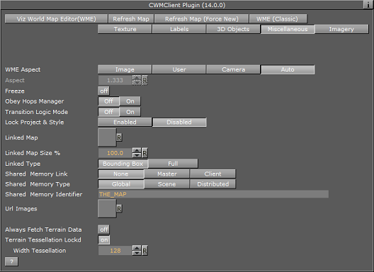
WME Aspect– Defines the aspect of the map in the WME window:
-
Image: When enabled, the aspect is set by the texture size defined in the texture screen of the CWMClient plugin.
-
User: When enabled, the user can manually set the aspect. When selected, the Aspect parameter will be enabled. The aspect is modified by changing the aspect value.
-
Camera: Sets the aspect to be the same as the current camera in use. Selecting this option will therefore open the WME in the same aspect as the current camera.
-
Auto: When enabled, the plugin will look for a Navigator plugin in the hierarchy, above the CWMClient plugin. If a Navigator is found the camera aspect will be used. If the Navigator plugin was not found, the image aspect will be used.
-
-
Freeze: When enabled (On), the map retrieved from the server will be saved as an image in the Viz image library and used as a static geo-referenced image. All map dynamic parameters will be hidden.
-
Obey Hops Manager: When turned ON, all the settings of labels/regions/3D Objects will be defined in the Hop Manager Plugin. When set to OFF these settings will be local to this CWMClient Plugin.
-
Transition Logic Mode: When set to Off, the plugin will request the map from the server or cache when the scene is loading. If Transition Logic Mode is enabled (On), the scene will load without requesting a map since the control application (e.g. Viz Trio or another external application) will send the parameters for a map to use. This option saves time during initialization of scenes using a dynamic map.
-
Lock Project & Style: Will lock the CWMClient Plugin to only use the selected TPL and style sheet and ignore any changes made from the WME.
-
Is Linked to Master Map: When the Is Linked to Master Map parameter is set the CWMClient (slave) is controlled by another CWMClient (master). To control another CWMClient, drag and drop a container with a CWMClient (slave) plugin onto the CWMClient (master) plugins’ Linked Map placeholder (see next parameter).


-
Linked Map: When set, this parameter is a container placeholder that defines the map (slave) that will be linked to the current map (master). The linked map is another CWMClient container that will receive the same map as the map selected from the WME.
-
Linked Map Size: Defines the size of the linked map as a percentage from the main map, that is if 50% is defined the linked map will show half of the area defined in the main map.
-
Linked Type (advanced): Should the link type only include bounding box or should it include all the data (regions, labels etc.).
-
Shared Memory Link: Defines which is the master (source) and client (target) when the same Shared Memory Identifier is used.
-
Shared Memory Type: Defines the accessibility of the shared memory.
-
Global: Memory is accessible to all scenes currently loaded in memory. This is useful when working with Transition Logic scenes where your Viz World map can be one scene and the locator a different one and data can easily be transferred between the two.
-
Scene: Memory is only accessible locally and to the current scene. Every scene has one shared memory map that can be used to exchange data among the scripts in the scene.
-
Distributed: Memory is accessible to all computers connected to one Viz Graphic Hub.
-
-
Shared Memory Identifier: Defines the identifier for the shared memory map.
-
Url Images: Container holding the Url Image manager which will be invoked when the map changes.
-
Always Fetch Terrain Data: When enabled the plugin will always fetch terrain data.
-
Terrain Tessellation Locked: Appears when a C3DTerrain plugin is combined with the CWMClient plugin.
-
Tessellation is the terrain resolution, which is the number of polygons used to build the terrain object. The higher the tessellation, the more detailed the terrain will be. Use the Width Tessellation and Height Tessellation parameters to fine tune the quality versus the performance of the scene.
-
When set to On, only the Width Tessellation parameter can be changed; hence, the setting will apply for both Width and Height.
-
When set to Off, the parameters can be set individually.
-
Imagery
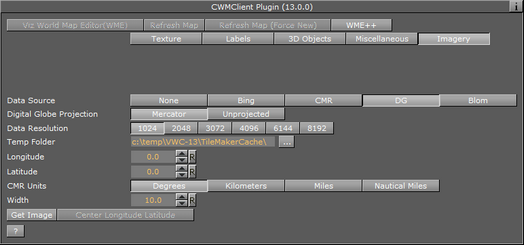
The Imagery section includes multiple imagery configuration options.
-
Data Source: Defines the source of the imagery. Available options are Bing (MIcrosoft Bing server), CMR (Curious Multi-Resolution imagery), Digital Globe (DG) or Blom.
When enabled (On) additional parameters are made available, and the WME button is disabled.-
Data Resolution: Available resolutions in pixels (i.e. width).
-
Temp Folder: Sets a temporary download folder.
-
Data Type: (Visible when Data Source is Bing). Available data types are satellite, map or a combined type of imagery.
-
CMR: (Visible when Data Source is CMR). Defines a CMR file to be used as a source for the map.
-
Digital Globe Projection: (Visible when Data Source is DG). Allows you to select the DG project. Currently available as Mercator and Unprojected.
-
-
Longitude: Sets the map longitude.
-
Latitude: Sets the map Latitude.
-
CMR Units: Sets the Curious-Multi Resolution imagery’s units to degrees, kilometers, miles or nautical miles.
-
Width (deg): Sets the area width in degrees, kilometers, miles or nautical miles.
-
Status: Displays the current CMR operation status.
-
Get Image: Retrieves the defined imagery (of the area defined by Lon, Lat and Width parameters).
-
Center Longitude Latitude: When clicked, the CMR will be created with the longitude and latitude values as the center of the CMR.
Note: The longitude and latitude values must be within the CMR area. If the values are not within the CMR area no map will be created.
Buttons
The following default buttons apply to the plugin as a whole.
-
Viz World Map Editor (WME): Opens the WME. WME connects to Viz World Server that is defined in Viz Config, and retrieves the current map or opens the defined default project if no map exists (fresh plugin instance).
-
Refresh Map: Re-draws the map and refreshes the related Viz objects using Viz World Client (WoC)plugins in the scene hierarchy. For example if a label design has been changed in Viz Artist, clicking Refresh Map will redraw the map with the new label design without opening WME.
-
Refresh Map (Force New): Re-creates the map on the server and saves it to the cache. This operation will force the map creation, even if the map exists in the cache folder.
-
WME (Classic): Will open WME Classic interface instead of the new WME
Search Order
The CWMClient can hold designs for labels and 3D objects such as regions, borders and shapes. As the designs can be stored in the scene or on the Viz Graphic Hub (i.e. Viz-DB) you need to understand the order in which these designs are searched for.
The following rules apply when searching for designs under the Design holders.
Example I - Add Label Map Tool Bar
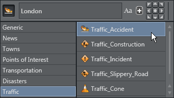
If, when using the World Map Editor or Map Editor Classic, you add a label and set the style to be Traffic_Accident, the search order will be based on the following rules:
-
Search the Scene - that may have multiple designs where each design has a name that corresponds to its design.
-
Search Viz Graphic Hub (i.e. Viz-DB) - that may have multiple designs stored in a design folder where each design is a merged object with a name that corresponds to the design.
First the Scene design holder is searched (if used) in the following order:
-
By Style
-
By Design (Point_Label)
-
By Default Design (Default_Design)
This means that it will search for and use:
-
Traffic_Accident, and if not found then
-
Point_Label, and if not found then
-
Default_Design
If none were found, the Viz-DB design holder is searched in the same order.
Example II - Add label Search Tab
If, when using the World Map Editor or Map Editor Classic, you search for and add a Town with more than 1 million (Towns > 1m) inhabitants as a label to the map and for the CWMClient set the style to be “Bigtown” the search order will be based on the following rules:
-
Search by style only if different than Place
-
By detail (Capital / Town_1m / Town_100k / Town_10k / Town_1k / Town)
-
By default town design (Default_Town)
-
By style (if = Place)
-
By default design (Default_Design)
This means that a search will search for and use:
-
Bigtown, and if not found then
-
Town_1m, and if not found then
-
Default_Town, and if not found then
-
Place,
-
Default_Design
Naming conventions
Note: Names using letters other than [a-z A-Z 0-9] will be converted to _ (underscore).
As there are several types of labels the following is the search order for each label type:
-
Capital
-
Town 1M
-
Town 100K
-
Town 10K
-
Town 1K
-
Town
-
Search by style only if different than Place
-
By detail (Capital / Town_1m / Town_100k / Town_10k / Town_1k / Town)
-
By default town design (Default_Town)
-
By style (if = Place)
-
By default design (Default_Design)
-
-
Region:
-
By style
-
By region level (Country / Region / Sub_Region)
-
By detail (Region)
-
By default design (Default_Design)
-
-
Point Label:
-
By style
-
By design (Point_Label)
-
By default design (Default_Design)
-
-
None of the above:
-
Search by style only if different than Place
-
By default design (Default_Design)
-
-
All Others:
-
Search by style only if different than Place
-
By detail (Region / Region_Name / River_Name ...)
-
By style (if = Place)
-
By default design (Default_Design)
List of details name:
-
-
Capital
-
Town_1m
-
Town_100k
-
Town_10k
-
Town_1k
-
Town
-
Tourist_Attraction
-
Reserve_Or_Park
-
Region_Name
-
Physical_Area_Name
-
Physical_Water_Name
-
River_Name
-
Mountain_Name
-
Label
-
Street_Address
-
Intersection
-
Traffic_Incident
-
Traffic_Accident
-
Traffic_Construction
-
Traffic_Speed
-
Point_Label
-
None_Of_The_Above
-
Region