
Viz World User Guide
Version 17.0 | Published January 24, 2018 ©
Globe
![]()
The plugin can be found in the folder: Viz Artist 3: Built Ins -> Geom Plugins -> Maps.
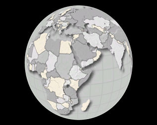
The Globe plugin is used as a base object, with maps, to enable geographic referencing options over a globe. The globe object will geographically reference the map at the correct location over the globe.
The plugin has three views:
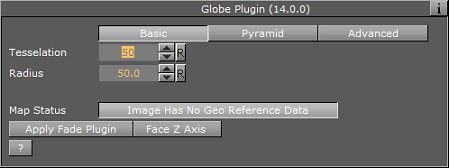
Basic
-
Tessellation: Defines the number of polygons used to create the Globe geometry.
-
Radius: Defines the radius of the globe.
-
Map Status: Reports if the map was loaded as expected (Ok), geographic referencing of the map, and so on.
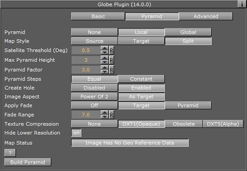
Pyramid
-
Pyramid: When to set to None or Local this uses the local parameters. When set to Global, it uses the parameters as defined in the Hops Manager.
-
Map Style: Defines the map style to be used for the pyramid maps:
-
Source: Uses the top CWMClient container ( Map Tiler ) style selection when creating the pyramid maps.
-
Target: Uses the hop CWMClient style selection when creating the pyramid maps.
-
Split: Splits the pyramid layers style, based on image latitude and longitude size. If the image size is smaller then the threshold the target style will be used, if larger then the source style will be used. Additionally, it is possible to turn on the color correction option in Pyramid Control which will color correct the target image to match the source images. Set the Satellite Threshold (deg).
-
-
Max Pyramid Height: Defines the maximal number of maps that will be created in the pyramid. The optimal number of pyramid maps is calculated by the MapPyramid plugin. If the optimal number exceeds the Max Pyramid Height value, then the plugin will generate the maximal number defined.
-
Pyramid Factor: Calculates the number of maps required defining the size factor between the maps of the pyramid.
-
Pyramid Steps: Defines how the map coverage area grows from pyramid to pyramid:
-
Equal: The size factor will be based on map pyramid height, pyramid factor and the resolution difference between the base map and the final map. The actual number might be different than the pyramid factor. The number of levels might also be smaller than the max pyramid height
-
Constant: The value of the pyramid factor will be used as is, with the value of max pyramid height.
-
-
Create Hole: Will create a hole on each pyramid tile
-
Image Aspect: (Power of 2). Will calculate the closest power of 2 size, based on the selected image size of the CWMClient Plugin texture size. Target will use exactly the same size as the CWMClient Plugin texture size.
Note: It is recommended to use this setting to improve performance.
-
Apply Fade: Defines whether the maps used in the pyramid will use soft edges. Available options are Off, Target and Pyramid.
-
Off: No soft edges will be used. The transition between the maps will be visible (the maps will have sharp edges).
-
Target: Sets the last map (target) to have soft edges only.
-
Pyramid: Sets all maps in the pyramid to have soft edges.
-
-
Fade Range: When Apply Fade parameter is used, the Fade Range is used to set the fade level (the area of the image that the fade will be applied to).
-
Texture Compression: Select one of the required compression modes for the images.
-
Hide Lower Resolution: Defines whether the map created by the CWMClient plugin, located on the MapPyramid container, will be turned off when the texture resolution of that map is lower than the Globe or GeoImage map tiles resolution. If it is enabled (On), the maps with lower resolution will be turned off automatically by the MapPyramid plugin. If it is disabled (Off), the MapPyramid will not turn off the low resolution maps.
-
Map Status: Status of the map.
Advanced

-
Sub Tessellation: This parameter divides each of the Globe flat areas, to increase texture coordinates and improve the way the textures look on a globe.
-
Texture Mapping: This parameter defines how the texture (map) will be mapped over the Globe:
-
Absolute: The globe object will be cropped according to the values set in the West, East, South and North parameters.
-
Relative: The globe object will be cropped according to the geographical properties of the map applied to the Globe.
-
GeoRef: The map will be mapped over the globe object according to its geographical properties.
-
-
West/East: Sets the Longitude value for the western/eastern edge of the Globe. The globe object will be cropped at that Longitude.
-
South/North: Sets the Latitude value for the southern/northern edge of the Globe. The globe object will be cropped at that Latitude.
-
Enable Hole: Saves performance when building pyramids using globe objects. When the globe objects for the pyramid layers are created, a hole is created where the higher resolution maps are, to avoid rendering multiple pixel layers (and to save performance). It can be used manually to create a hole in a globe object by setting values which are in the area of the map in use. When enabled (On) additional parameters will be enabled:
-
Hole West (From lon): Defines an inner Longitude in the map area where the hole will begin (West side).
-
Hole East (To lon): Defines an inner Longitude in the map area where the hole will begin (East side).
-
Hole South (From lat): Defines an inner Latitude in the map area where the hole will begin (South side).
-
Hole North (To lat): Defines an inner Latitude in the map area where the hole will begin (North side).
-
-
Avoid Radius Cheat: The plugin contains a Radius setting that can be avoided if required.
Note: This is a very advanced feature which should be used with caution.
Buttons
-
Build Pyramid: Rebuild the pyramids
If Pyramid is set to None in the Pyramid tab, then the available buttons are:
-
Apply Fade Plugin: When clicked, a Fade Texture plugin will be applied to the container.
-
Face Z Axis: When clicked, the globe object will rotate and centre facing the Z-axis. This button can be used when not a full globe is rendered (for example only Asia). Do not use this feature with the Navigator plugin as it assumes no rotation.