
Viz World User Guide
Version 17.0 | Published January 24, 2018 ©
Atlas
![]()
The plugin can be found in the folder: Viz Artist 3: Built Ins -> Geom Plugins -> Maps.
The Atlas plugin is used for displaying satellite imagery from Microsoft Bing, Digital Globe, Google and other providers. This object plugin is used with a navigator plugin, enabling interactive navigation to any location on Earth. The plugin can be used to display imagery for a Navigator animation (Hops), while creating the required image tiles for a smooth and complete camera movement. It can also be used with the Globe plugin.
To create an interactive Touchscreen Application, the Atlas Plugin must be used together with the Navigator.
IMPORTANT! To ensure that image tiles appear correctly, use a base map with the correct projection.
The plugin has the following plugin editor tabs;
Data
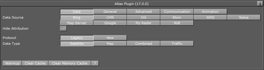
The Data tab is used to define imagery parameters.
-
Data Source: Sets the data provider. Available providers are:
-
Microsoft Bing
-
Vizrt’s CMR (Curious Multi Resolution)
-
DG (Digital Globe)
-
WMS (Web Map Service) geo server
-
myRadar Weather Radar.
-
Weather Decision Technoloies (wdt)
Note: Bing, Blom, DG, WMS and Google require an internet connection. Bing, Blom and Google will not work without a license, DG will, but will show a watermark.
-
-
Hide Attribution:
Some data sources provide the possibility to hide the provider's attribution.
This is different for every data source. Some provide a separate license to enable this feature.
Bing
-
Protocol:
If Legacy is selected, the API used in previous versions of VizWorld will be used.
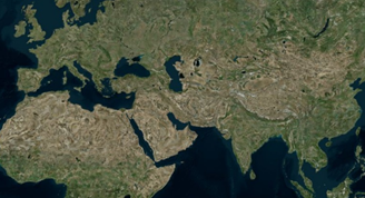
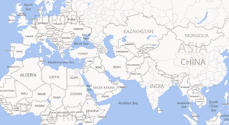
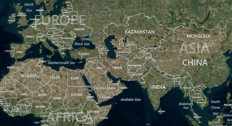
You can use the Data Type parameter to choose between satellite imagery, road and border maps with labels or a combination of the two. If you combine the two road and border maps with labels they will be imposed over the satellite imagery.-
Satellite: Will display ONLY satellite imagery.
-
Map: Displays the map using the hybrid styling and will also display labels
-
Combined: Will be a mix of Satellite imagery and Labels
-
Traffic: Draws a traffic layer
If New is selected, a new API is used, which gives you more control over what to display in the map. It will allow you select whether or not to include labels in the map, and what language to use for those labels. The following parameters are available: -
Map: Display Satellite imagery, or display the Map using the hybrid styling.
-
Labels: Turns the labels in the Map on/off.
-
Culture: Allows you to select the language of the labels
-
Vector: Determines whether or not the map will include vector data (streets/ borders) with the satellite imagery.
-
Hills: Determines whether or not the synthetic map will include hills topography.
-
CMR
-
CMR File: Sets the path to the CMR file.
-
CMR Data Status: Indicates whether or not the file was loaded correctly.
DG
-
Projection: Defines the projection of the map, either Unprojected or Mercator.
-
Digital Globe Profile: Enables you to select from the most common profiles of Digital Globe maps (Note that imagery from different profiles may differ in some places and be the same in others).
In addition, the following parameters can be configured in the VizWorld.ini configuration file (by default located at C:\ProgramData\vizrt\viz3\Maps):
-
DigitalGlobePrefix
-
FirstLookPrefix
If these parameters are used (i.e. present and not commented with hash) then Atlas will use these strings as the basic connection string. The license key, projection, tile coordinates and additional parameters like profile or header will be added in Atlas itself.
Blom
-
Data Type: Sets how the map will be displayed. For more information, see the description of the Data Type parameter in the Bing tab.
WMS
-
Projection: Defines the projection of the map, either Unprojected or Mercator.
-
Url: Sets the Url of the WMS geo server.
-
Layer: Comma-separated list of one or more map layers. Values in list correspond to the layer <Name> values by the geo server’s Capabilities file. Layer list is optional if the Styled Layer Descriptor (SLD) parameter is present in the request.
-
Free text: Used to set optional parameters like transparency and background color (e.g. TRANSPARENT=TRUE&BGCOLOR=#E98300&). For more information on how to set optional parameters in the free text field, see the WMS specification documentation.
-
Version: Request version. Valid values are 1.0.0, 1.1.0, or 1.1.1.
Nokia
-
Data Type: Sets how the map will be displayed. For more information, see the description of the Data Type parameter in the Bing tab.
Map Server
This will allow the use of the TPLs and stylesheets in an available map server.
-
Server Configuration:
-
Default: Will use the default server configured in the engine (See 2017-11-10_15-18-11_Viz Engine Configuration).
-
Manual: Will allow you to use a different server than what is configured in the Viz Engine.
-
-
Projects: Will list all TPLs that are available in the map server
-
Project: Will display the selected TPL
-
Pick Style: Numerical index of the available style sheets in the selected TPL
-
Layer: Name of the selected Style sheet
Note: In the Viz Artist interface, a maximum of 256 TPLs can be displayed.
-
Profile XML Status: Shows if the file GoogleMaps_Profiles.xml (by default located at C:\ProgramData\vizrt\viz3\Maps) was read correctly.
-
Google Profile: Lists all found profiles from the file GoogleMaps_Profiles.xml.
Note: To add or modify Google profiles, edit the file GoogleMaps_Profiles.xml. The Google Maps Tile documentation lists all possible configurations.
More information can be found at Google Maps Profiles.
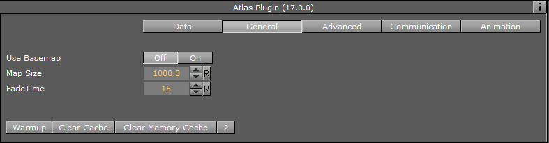
General
-
Use Base Map: This option is used when working with a base map above the Atlas container, and the base map is projected. Note that Microsoft Bing imagery is unprojected, so in order to have the images positioned correctly over the map set this parameter to On. The same applies if you use the Globe plugin.
-
Map Size: Defines the size of the Atlas image.
-
Fade Time: Defines the duration of the transition between tile resolutions when zooming in/out of the image.
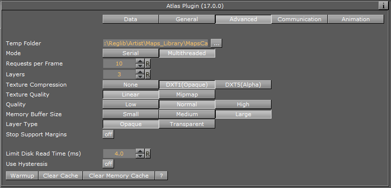
Advanced
The Advanced tab is used for configuring connection and operation parameters.
-
Temp Folder: Defines a specific cache folder for the retrieved imagery.
-
Mode: Defines the mode of retrieving the tiles from Microsoft Bing server. When set to Serial, and new image tiles are required, Atlas plugin will send a request to the server and wait for a reply. Only after the reply another tile will be requested, and so on. During the time that the plugin as waiting for a replay the UI is locked the user cannot perform other operations. When set to Multithreaded, the images are requested by a thread of the plugin and the UI is not locked.
-
Requests per Frame: Defines the maximal image requests from the server in a frame.
-
Layers: Defines the number of images (with different resolution) per one area.
-
Texture Compression: Select one of the required compression modes for the images.
-
Texture Quality:
-
Linear: Performs a linear interpolation to smooth the texture when being magnified or shrunk. The texture looks good, but some distortions can be visible when the textured object is animated further away on the Z axis. As the object then gets smaller and smaller, the shrinking and interpolation of the texture creates a lot of "noise" on the texture. As a consequence, the linear quality is appropriate when the objects that have the texture do not change their size much.
-
Mipmap: Performs a linear interpolation to smooth the texture. In addition, it offers a solution to the problem that appears on the two other qualities when the object is being moved away along the Z axis or shrunk. To avoid the "noise" that we see when a texture constantly scales to try to fit.
-
-
Quality: Defines the quality of the images requested from the server.
-
Memory Buffer Size: Option to control memory buffer used by Atlas. Useful for scenes with multiple Atlas plugins.
-
Layer Type: Selecting a transparent layer type you will be able to maintain transparency while stacking multiple layers on top of each other. Selecting opaque you will consequently block anything below it. WMS layers tend to be transparent (e.g. power lines or flood area). This parameter is only visible when the Data Source is set to WMS.
-
Stop Support Margins: When set to ON, additional image tiles surrounding the displayed area will be retrieved, to enable immediate display of high resolution images when the user moves the image.
-
Limit Disk Read Time (ms): This parameter specifies the maximum time period for the plugin to be occupied with loading. If while loading the tiles for the current frame, the plugin recognizes that loading is taking too much time, it will stop loading and render the frame.
-
Use Hysteresis: This option resolves the ’flickering problem’ that may occur if the Navigator position moves back and forth around a point where the plugin decides to change resolution levels. Hysteresis uses history data in the calculation of a point where the level should be changed, such that the switch for zoom in and zoom out will not happen in the same point, thus avoiding the flickering. If enabled, set the Hysteresis size.
-
Set Proxy (button): Applies the proxy settings.
-
Tessellation: Only visible when Atlas is used under basemap. The Tessellation parameter is used to increase tessellation of each tile in the Atlas plugin. This may be useful when projection of the basemap differs from the projection of Atlas data source (and one of the projections is not linear). By using tessellation, the tile fits more accurately to the basemap (less distortion). Raising this parameter affects performance, so only use when distortion due to a difference of projections is visible and unacceptable.
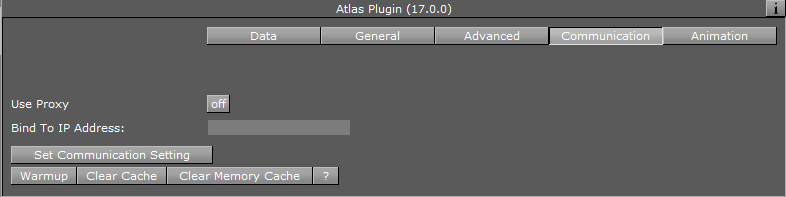
Communication
-
Use Proxy: When set to ON, proxy configuration parameters will be enabled. Use this option when working an a network with proxy:
-
IP: Proxy server IP number
-
Port: Proxy port number
-
Username/Password: Sets the username and password.
-
-
Bind to IP Address: When set, this forces the plugin to use the IP address of a specific network card in the computer (used when multiple network cards are part of the computer). When not set, it defaults to the first network connection.
Animation
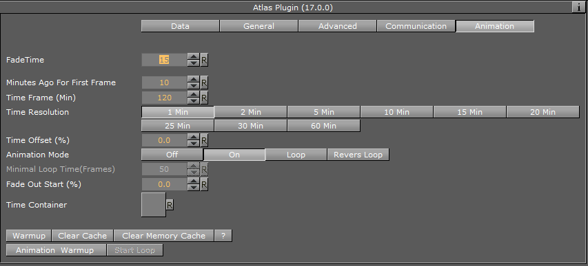
The animation properties are only valid if the DataSource is set either to "My Radar" or to " Weather Decision Technoloies ". It gives access to advanced options on how different animation slides are being displayed.
Buttons
-
Warm up: Prepares all image tiles for a defined animation. Once tiles are in the cache folder, the animation will play smoothly.
-
Clear Cache: Will clear and delete all imagery in the cache folder defined under the folder Advanced/Temp.
-
Clear Memory Cache: Will clear the Viz memory and reload the images.